Sections
About us
Contact us
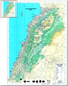
Map of Lebanon, 2012
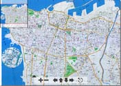
Map of Beirut, 2012
Maps of Beirut and Lebanon, details map, street, map directions, borders, tourist, detailed map
Cities and Towns of Lebanon: Beirut | Jounieh | Tripoli | Tyre | Zahleh | Jbeil-Byblos | Saida Paper Maps, square by square: Map of Lebanon - Map of Beirut
Panoramic Views | Photos | Ecards | Posters | Map | Directory | Weather | White Pages | Recipes | Lebanon News | Eco Tourism Phone & Dine | Deals | Hotel Reservation | Events | Movies | Chat | Wallpapers | Shopping | Forums | TV and Radio | Presentation
Advertise | Terms of use | Credits